


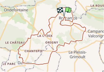
ROUCAMPS 18 TER def ?

UDGI54
User

Length
24 km

Max alt
356 m

Uphill gradient
439 m
Km-Effort
30 km

Min alt
200 m

Downhill gradient
439 m
Boucle
Yes
Creation date :
2019-01-15 18:44:55.291
Updated on :
2019-01-15 18:44:55.291
6h41
Difficulty : Unknown

FREE GPS app for hiking
 SityTrail
IGN / Geographical institutes
SityTrail Plus
The world is yours!
About
Trail Walking of 24 km to be discovered at Normandy, Calvados, Les Monts d'Aunay. This trail is proposed by UDGI54.
Positioning
Country:
France
Region :
Normandy
Department/Province :
Calvados
Municipality :
Les Monts d'Aunay
Location:
Roucamps
Start:(Dec)
Start:(UTM)
673683 ; 5429207 (30U) N.
Comments